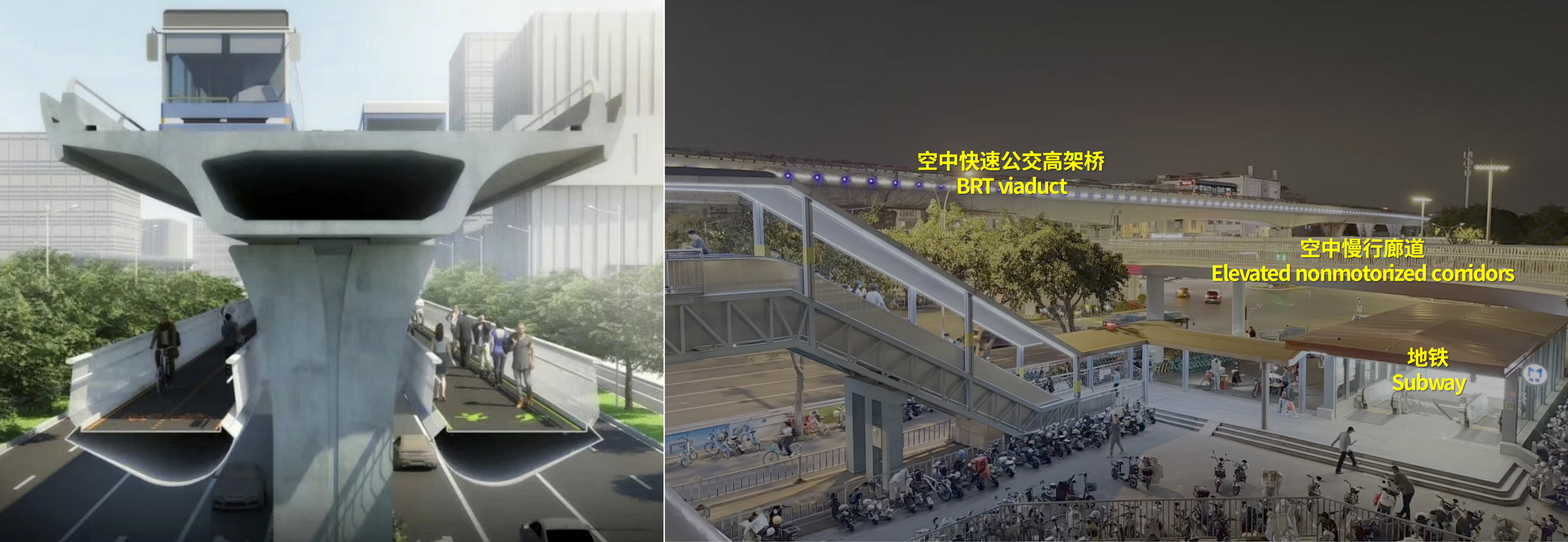
Xiamen Mountains-to-Sea Trail: Elevated Nonmotorized Corridor Solving the Urban Spatial Fragmentation
Turning Viaduct “Concrete Walls” into Inclusive, Green, People-Centred Public Space
The Initiative
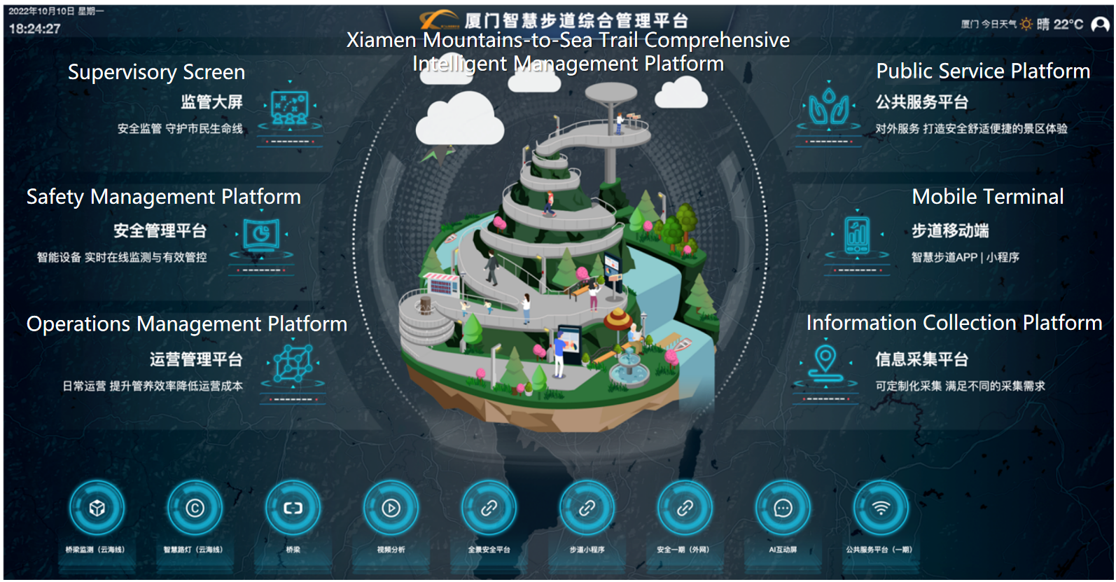
The construction of elevated viaducts has led to fragmented urban spaces, poor connectivity, lack of interaction in some communities, and infringed mobility rights for vulnerable groups. To address this bottleneck, Xiamen has built elevated nonmotorized corridor named “Xiamen Mountains-to-Sea Trail” using the under viaduct spaces of the elevated Bus Rapid Transit (BRT) lanes, which lie between the BRT viaduct and the ground arterial roads, without excessive land occupation. Integrated with the metro and BRT systems, a three-dimensional transport network of “rail + bus + nonmotorized travel” is created to connect communities, commercial zones and transport hubs. Supported by Park and Ride (P+R) facilities and smart mobility platforms, the project has improved transport efficiency, revitalized communities, increased green travel share and delivered inclusive, barrier-free access for all.
The Challenge
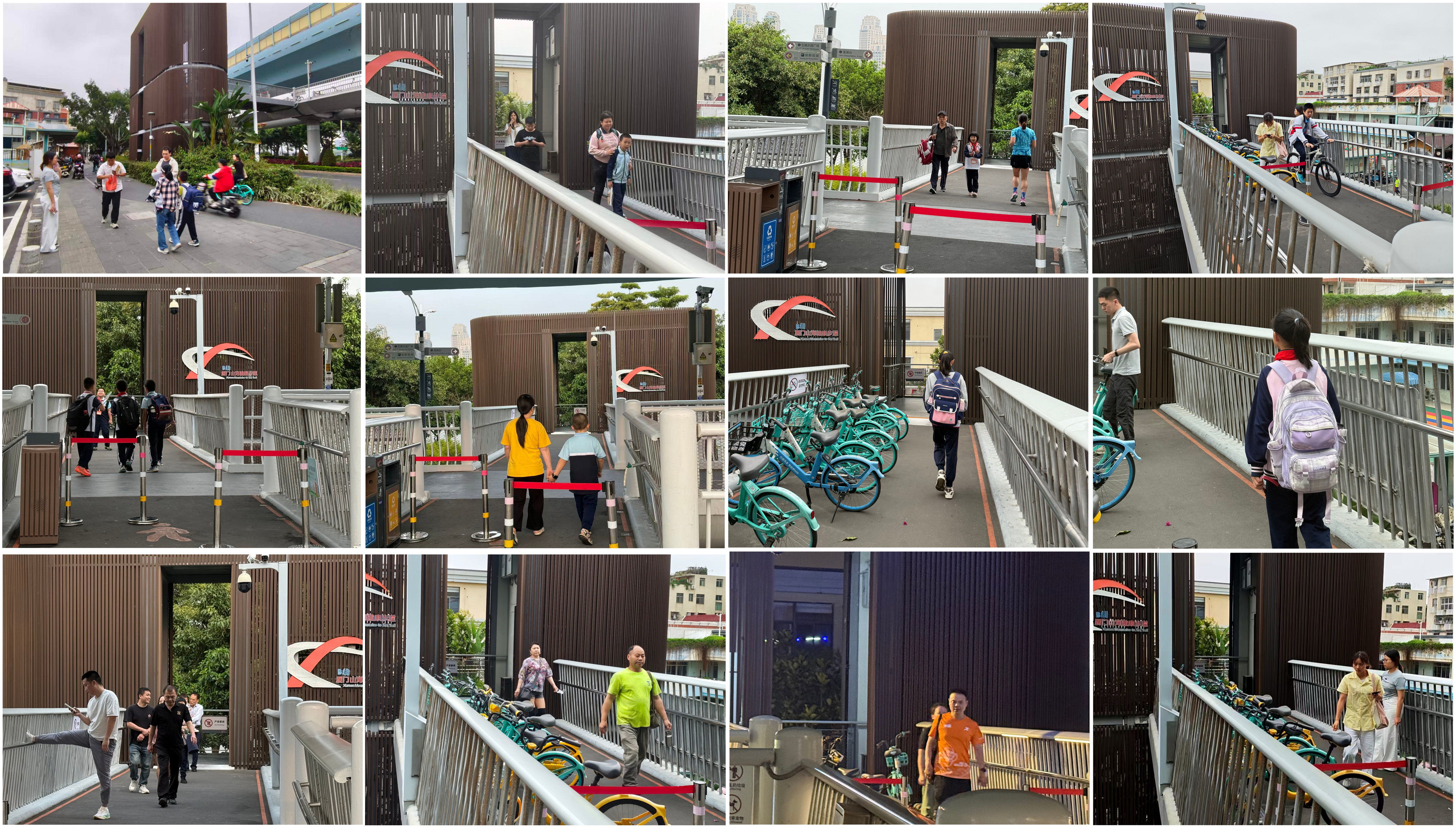
Before the trail: viaducts as "concrete walls"
Before the trail was completed, elevated BRT viaducts across Xiamen created serious physical barriers between communities. Residents — especially students, seniors, and people with disabilities — faced long detours, heavy traffic risks, and inefficient crossings. Students at Dongfang Primary School had to cross busy arterial roads with no safe access. Urban spaces were disconnected, and vulnerable groups' mobility rights were compromised. Urban planning used to prioritize vehicle flow over pedestrian needs , resulting in low connectivity, insufficient public space, and unbalanced urban vitality.
The Innovation
The project adopts a three-dimensional space reuse model without additional land occupation, transforming under-viaduct and overhead spaces into a continuous nonmotorized corridor.

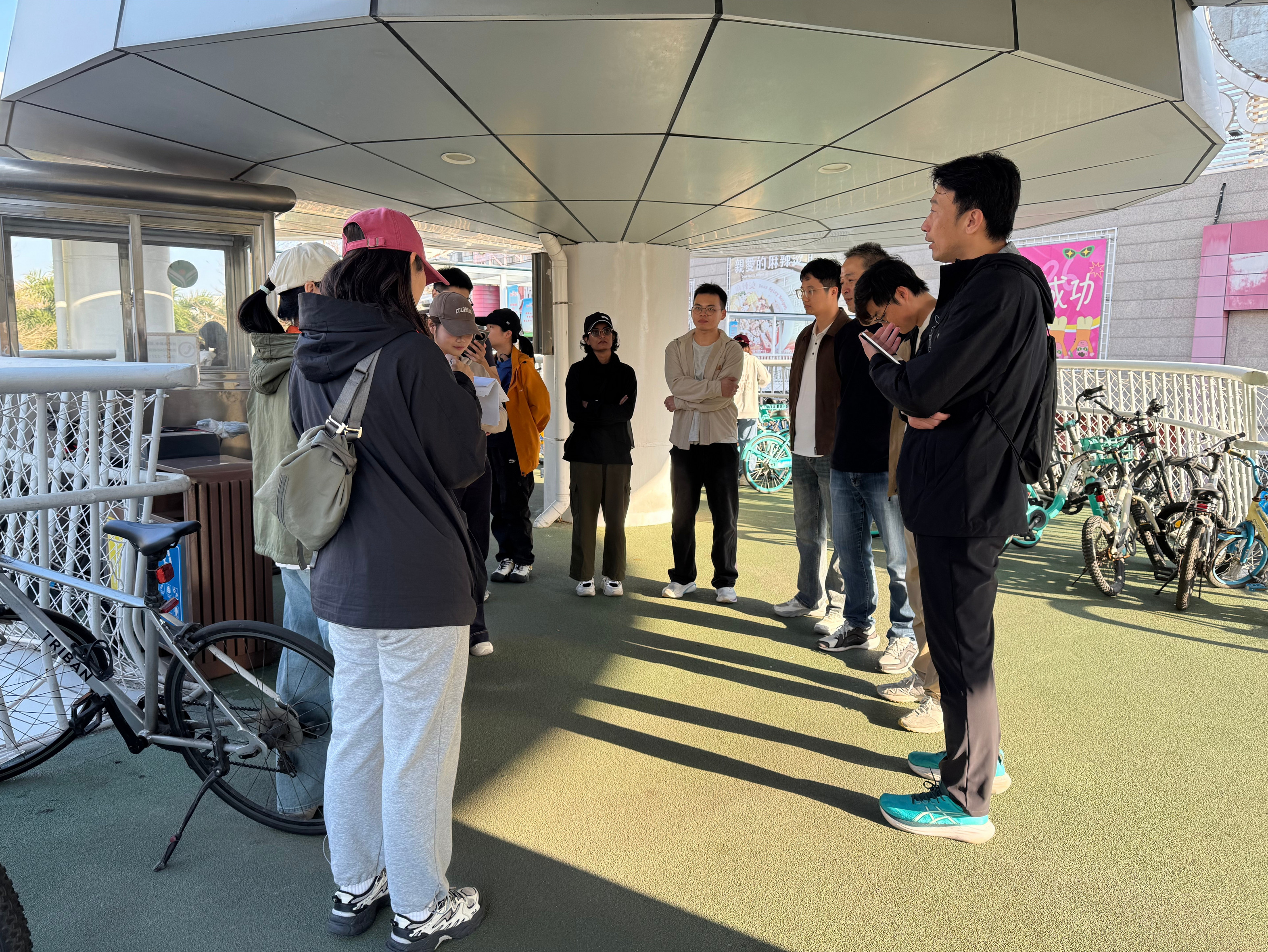
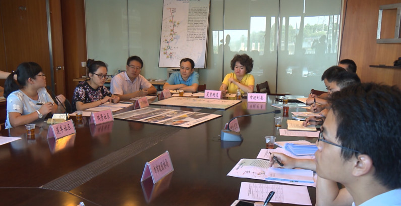
Governance & Partnership
The project follows a people-first governance philosophy, implementing a "government leadership, enterprise implementation, multi-stakeholder collaboration" mechanism.
The Xiamen Municipal Government established an inter-departmental joint working group for overall planning and coordination. Municipal state-owned enterprises are responsible for construction, operation and maintenance.
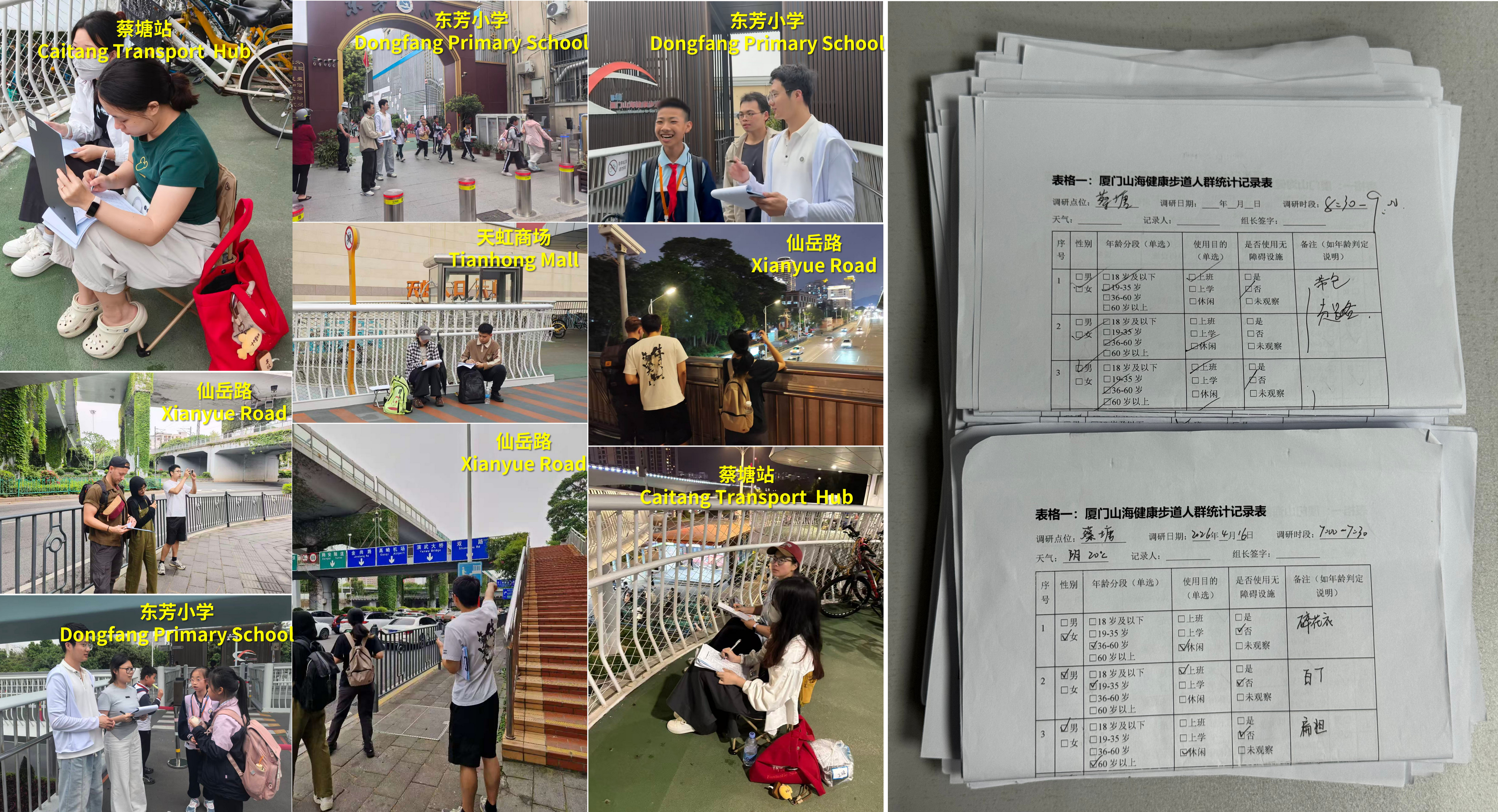
Impacts & Results
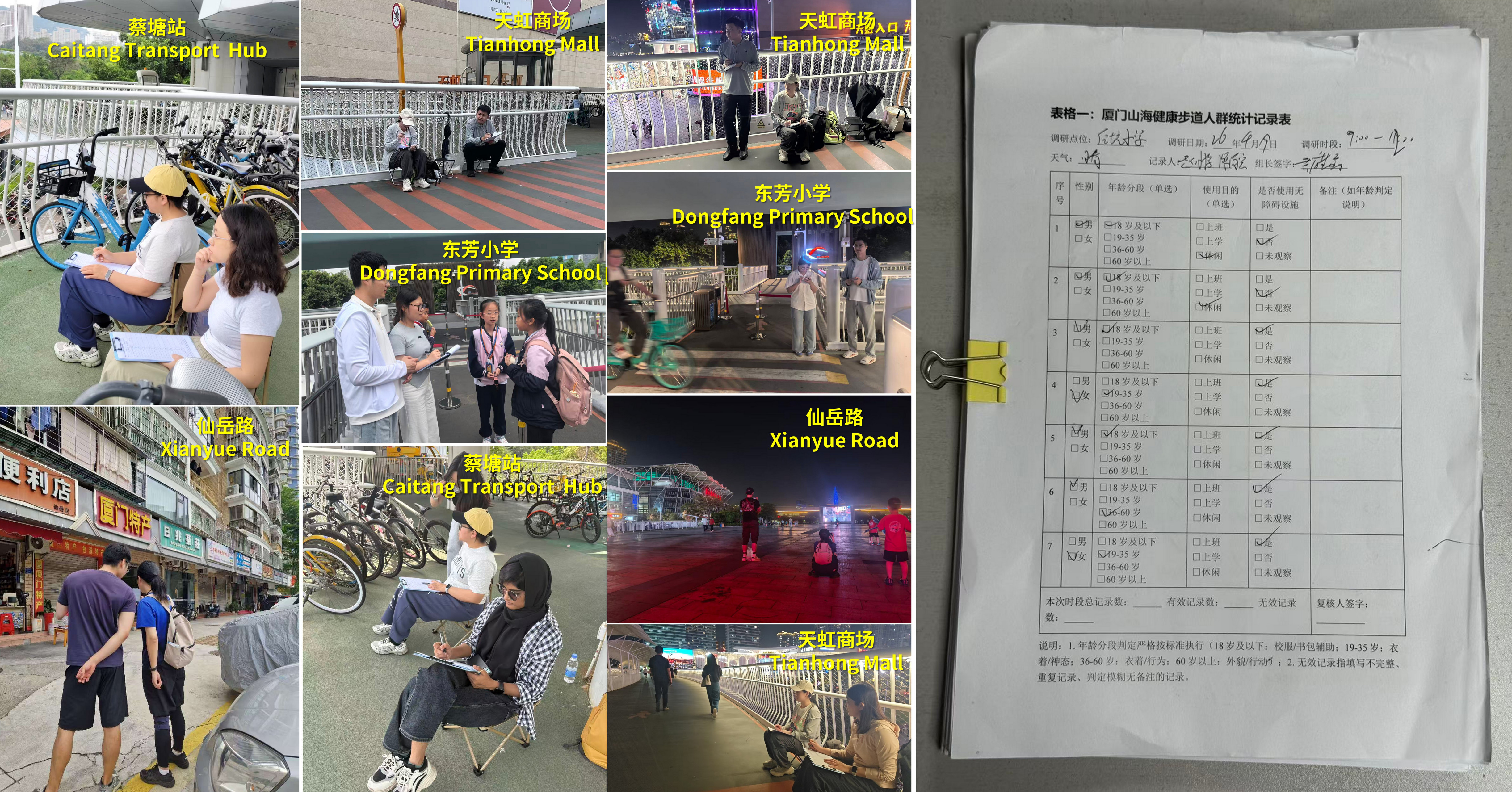
Significant and quantifiable outcomes, supported by on-site surveys at Caitang Transport Hub, Tianhong Mall, and Dongfang Primary School.
| Survey Location | Valid Samples | Gender Ratio | Age Distribution | Travel Purpose | Travel Time Comparison | Accessibility Usage | Remarks |
|---|---|---|---|---|---|---|---|
| Caitang Transport Hub 蔡塘交通枢纽 | 1,701 | M: 56.08% / F: 43.92% 男: 56.08% / 女: 43.92% |
<18: 3.47% 19–35: 37.15% 36–60: 53.62% >60: 5.76% 18岁以下: 3.47% 19–35岁: 37.15% 36–60岁: 53.62% 60岁以上: 5.76% |
Commuting: 26.46% School: 2.12% Leisure: 71.43% 通勤: 26.46% 上学: 2.12% 休闲: 71.43% |
Before: 8:35 After: 6:58 ↓ 18.83% 建设前: 8分35秒 建设后: 6分58秒 ↓ 18.83% |
0 users / 0% 0人 / 0% | Under maintenance 无障碍设施维修 |
| Near Tianhong Mall 天虹商场附近 | 998 | M: 62.63% / F: 37.37% 男: 62.63% / 女: 37.37% |
<18: 3.61% 19–35: 40.38% 36–60: 40.28% >60: 15.73% 18岁以下: 3.61% 19–35岁: 40.38% 36–60岁: 40.28% 60岁以上: 15.73% |
Commuting: 22.14% School: 0.80% Leisure: 77.05% 通勤: 22.14% 上学: 0.80% 休闲: 77.05% |
Before: 12:55 After: 8:03 ↓ 37.68% 建设前: 12分55秒 建设后: 8分03秒 ↓ 37.68% |
0 users / 0% 0人 / 0% | Out of service 无障碍设施停用 |
| Near Dongfang Primary School 东芳小学附近 | 390 | M: 52.82% / F: 47.18% 男: 52.82% / 女: 47.18% |
<18: 15.13% 19–35: 29.23% 36–60: 43.59% >60: 12.05% 18岁以下: 15.13% 19–35岁: 29.23% 36–60岁: 43.59% 60岁以上: 12.05% |
Commuting: 19.49% School: 11.79% Leisure: 68.72% 通勤: 19.49% 上学: 11.79% 休闲: 68.72% |
Before: 13:51 After: 1:30 ↓ 89.17% 建设前: 13分51秒 建设后: 1分30秒 ↓ 89.17% |
209 users / 53.59% 209人 / 53.59% | — |
| Total 合计 | 3,089 | M: 57.18% / F: 42.82% 男: 57.18% / 女: 42.82% |
<18: 7.40% 19–35: 35.59% 36–60: 45.83% >60: 11.18% 18岁以下: 7.40% 19–35岁: 35.59% 36–60岁: 45.83% 60岁以上: 11.18% |
Commuting: 22.70% School: 4.90% Leisure: 72.40% 通勤: 22.70% 上学: 4.90% 休闲: 72.40% |
Avg. ↓ 48.56% 平均耗时降低 48.56% | — | — |
| Survey Location | Valid Samples | Gender Ratio | Age Distribution | Travel Purpose | Travel Time Comparison | Accessibility Usage | Remarks |
|---|---|---|---|---|---|---|---|
| Caitang Transport Hub 蔡塘交通枢纽 | 4,503 | M: 61.87% / F: 38.24% 男: 61.87% / 女: 38.24% |
<18: 26.74% 19–35: 33.20% 36–60: 31.49% >60: 8.59% 18岁以下: 26.74% 19–35岁: 33.20% 36–60岁: 31.49% 60岁以上: 8.59% |
Commuting: 0.69% School: 0.58% Leisure: 98.73% 通勤: 0.69% 上学: 0.58% 休闲: 98.73% |
Before: 8:35 After: 6:58 ↓ 18.83% 建设前: 8分35秒 建设后: 6分58秒 ↓ 18.83% |
0 users / 0% 0人 / 0% | Under maintenance 无障碍设施维修 |
| Near Tianhong Mall 天虹商场附近 | 7,440 | M: 50.62% / F: 49.38% 男: 50.62% / 女: 49.38% |
<18: 23.40% 19–35: 37.15% 36–60: 31.13% >60: 8.32% 18岁以下: 23.40% 19–35岁: 37.15% 36–60岁: 31.13% 60岁以上: 8.32% |
Commuting: 3.40% School: 0.40% Leisure: 96.20% 通勤: 3.40% 上学: 0.40% 休闲: 96.20% |
Before: 12:55 After: 8:03 ↓ 37.68% 建设前: 12分55秒 建设后: 8分03秒 ↓ 37.68% |
0 users / 0% 0人 / 0% | Out of service 无障碍设施停用 |
| Near Dongfang Primary School 东芳小学附近 | 1,379 | M: 50.54% / F: 49.46% 男: 50.54% / 女: 49.46% |
<18: 15.66% 19–35: 25.16% 36–60: 37.73% >60: 21.45% 18岁以下: 15.66% 19–35岁: 25.16% 36–60岁: 37.73% 60岁以上: 21.45% |
Commuting: 0% School: 0% Leisure: 100% 通勤: 0% 上学: 0% 休闲: 100% |
Before: 13:51 After: 1:30 ↓ 89.17% 建设前: 13分51秒 建设后: 1分30秒 ↓ 89.17% |
661 users / 47.93% 661人 / 47.93% | — |
| Total 合计 | 13,322 | M: 54.34% / F: 45.66% 男: 54.34% / 女: 45.66% |
<18: 21.93% 19–35: 31.84% 36–60: 33.45% >60: 12.79% 18岁以下: 21.93% 19–35岁: 31.84% 36–60岁: 33.45% 60岁以上: 12.79% |
Commuting: 1.36% School: 0.33% Leisure: 98.31% 通勤: 1.36% 上学: 0.33% 休闲: 98.31% |
Avg. ↓ 48.56% 平均耗时降低 48.56% | — | — |
Citizen Wellbeing & Urban Value
Xiamen Mountains-to-Sea Trail has become Xiamen's beloved "urban balcony." The project greatly improves living experience, enhances urban vitality, strengthens community connection, and increases public happiness and sense of gain. It transforms a single transportation facility into a multi-functional public space integrating commuting, leisure, sports, tourism and ecological experience.

Replication & Global Sharing
The Xiamen model provides a low-cost, replicable solution for cities worldwide facing urban fragmentation caused by elevated viaducts.
Xiamen is ready to partner with international organizations, cities and stakeholders to share this inclusive, green and sustainable urban innovation model with the world.